
Signed in as:
filler@godaddy.com
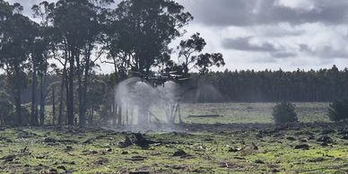
Unmanned Aerial Vehicles (UAVs) are revolutionizing large-scale farming, particularly in broadacre weed spraying, thanks to their numerous advantages. Drones have quickly become indispensable tools for professional farming in Australia, offering unmatched efficiency and precision.
Efficiency and Precision in Spraying
Our agricultural spraying drones significantly increase coverage and efficiency, delivering faster and more accurate spray applications over large areas compared to traditional backpack sprayers. With benefits like water conservation and precise chemical application, our drones ensure optimal results with up to 95% coverage, surpassing other aerial methods.
Comprehensive, Independent Service
Our operators are fully trained and licensed in chemical handling, ensuring safe and compliant application every time. Equipped with a Kestrel device, we record precise weather conditions to optimize spraying accuracy. Our setup includes a trailer and generator, allowing us to operate independently from the client. All we require from you are the crop details, the necessary chemicals, signed documentation, and property access.
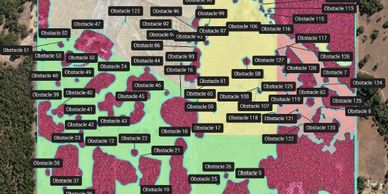
We harness the power of autonomous drones to perform precise 2D and 3D agricultural surveying. Our advanced multispectral camera drones enable us to create detailed ortho maps, which are essential for evaluating crop health. These insights help us target problem areas more effectively, reducing costs and improving overall efficiency.
Expert Drone Specialists
Our team of drone specialists are experts in utilizing cutting-edge technology for aerial mapping. Equipped with highly accurate navigation systems, our drones can survey large areas quickly and with precision, capturing intricate data that traditional methods often miss.
Benefits of Drone Mapping
Drones offer a faster, more cost-effective, and accurate alternative to traditional surveying methods. For instance, what might take a ground surveyor 2-4 hours to cover a quarter-acre lot, or 6-8 hours to survey a 3-acre area on foot, can be accomplished by a drone in just minutes. Drones easily navigate dense vegetation and challenging terrain, enhancing both safety and efficiency.

Our advanced aerial drone spreader is designed to efficiently disperse granular seeds, fertilizers, or pesticides over large areas. Capable of covering up to 5 hectares of land per hour, our drones accomplish in minutes what would take 150 laborers to complete manually.
Uniform and Precise Spreading for Maximum Impact
Achieve uniform spreading and seeding with our drone solutions, engineered for both efficiency and accuracy. Whether you're broadcasting seeds, applying fertilizers, or distributing cover crops, our drones ensure consistent coverage across your fields. Equipped with high-speed, focused airflow, the powerful spinner system precisely delivers granules exactly where they’re needed, optimizing crop health and yield.
Perfect for Challenging Terrain
Our drone spreading service is ideal for areas that are difficult to access with traditional machinery. We help you get the job done quickly and effectively, even in challenging conditions, ensuring your fields are treated with the utmost precision.

At OzGuard Drone Services, we offer efficient and precise drone whitewashing solutions for greenhouses, ensuring optimal light control and temperature regulation. Using advanced drone technology, we can evenly apply shading compounds to large greenhouse surfaces quickly and safely, eliminating the need for scaffolding or manual labour.
Benefits of Drone Whitewashing:
We primarily use ReduSystem products for our applications but are happy to accommodate other suitable alternatives based on your specific requirements.

We offer advanced thermal drone monitoring to assist farmers and land managers in efficiently tracking livestock and wildlife across large properties, day or night.
Our Services Include:
Using high-resolution thermal drones, we provide fast, non-intrusive, and cost-effective solutions for managing animals on your property.